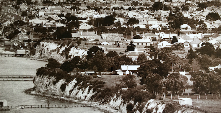
Smart part of town, the old Rippleside/St Helens enclave in Geelong’s bayside north.
Reclaimed and renovated within an inch of its life you might argue, it once hosted Aboriginal camps, marine slipworks and gypsies beneath its orange cliffs, with nunneries, a power station, even a submarine school above.
Today, it’s a smart inner suburb of waterside condos and yachts, slick architecture, clifftop homes with sprawling views, and a quiet ambience at odds with its busy highway trucks, traffic and trains nearby.
In fact, it’s a neat mix of old and new. Fruit trees, chicken runs and old parks alongside exquisitely landscaped gardens, minimalist homes and big diesel-guzzlers.
The street names hark to another era – Swinburne, Vautier, Bay, St David, Balmoral, Liverpool, Victoria – and there’s no shortage of evocative memories attached to them.
The red-brick North Geelong Primary School, now apartments after a curious fire, taught English to a couple of generations of migrants. The two-storey, verandahed Orient Hotel, a six o’clock closing icon, used to service the libation needs of workers heading home after a hard day’s slog in neighbouring heavy industries.
Slip back to 1938, as this Charles Pratt aerial shot does, and you’ll get a fair idea of a past peppered with jetties, piers, shacks and sheds, paddocks, eroding cliffs glued by unchecked vegetation and an abject lack of beachfront rounded out the surrounds.
You can see plenty of Geelong West and Newtown, too. Basically from the well-treed convent Stella Maris, with its twin chimneys and slate roof, in the foreground back to the Newtown hill fire station and slopes of Highton leading west to Ceres at the rear.
In between is St Helen’s Park and a shark-proof swimming enclosure out in the water. Today’s car park/playground area has yet to be reclaimed.
Rippleside Park with its harbour trust buildings and slipway is back a peg with cypresses and paths leading to the cliffs of Drumcondra, Green Gully and Western Beach.
The mass of rooftops belong to St Helen’s through Bay St to Drumcondra, the old Ashby sector of Geelong West and up to Newtown east.
Follow La Trobe up the hill and you’ll find Aberdeen with its Baptist church and well- camouflaged Newtown Club next door. Looking closely, move along the trees and houses of Aberdeen and you’ll hit Pakington Street and Ariston House.
The year, 1938, incidentally, marked the centenary of Geelong off9cially becoming a town in 1838.
Shutterbug pilot Charles Pratt captured numerous aerial photos of Geelong through the 1920s and ‘30s, the images cataloguing in great detail the city’s streets, stores and factories, houses, gardens, parks, public buildings, utilities, waterfront and natural surroundings.
The intensity of Geelong’s commerce and industry is powerful, from the CBD’s sawtooth roofs, store verandahs and smoke-belching chimneys to its shady parks and rotundas, classical public buildings and heavily populated grids of weatherboard homes.
This article appeared in the Geelong Advertiser 10 October 2022


